
China is building a bridge in eastern Ladakh connecting the north and south banks of Pangong Tso (lake). Which will considerably reduce the time from 12 hours to 3-4 hours for shifting armies and equipment between the two sides. So below the article, we are going to discuss all important points related to your UPSC IAS pre and mains.
About Pangong Tso:
India and China have unsettled borders, and the perception of the Line of Actual Control (LAC) differs in many sectors, comprising on Pangong Tso. The Line of Actual Control (LAC) – the line that separates Indian and Chinese troops since 1962 – generally runs along with the land except for the width of Pangong Tso. Here, it runs through the water.
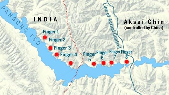
Both sides have marked their areas declaring openly which side belongs to which country. India controls about 45 km distance of the Pangong Tso and China the rest. The lake is divided into sections called fingers (1-8 fingers). India and China have a different understanding of where the LAC passes through.
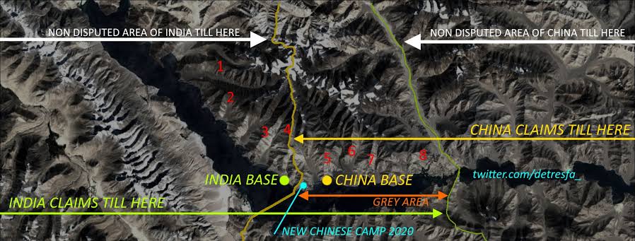
India has maintained that the LAC passes through Finger 8, which has been the site of the final military post of China. India has been protecting the area – mostly on foot because of the nature of the terrain – up to Finger 8. But Indian forces have not had active control beyond Finger 4.
China, on the other hand, says the LAC passes through Finger 2. It has been patrolling up to Finger 4.
Bridge over Pangong Tso?
The bridge over Pangong Tso is located around 25 km ahead of the LAC in Chinese territory and will significantly reduce the time for movement between People’s Liberation Army (PLA) garrison at Kurnak fort on the North Bank and the Modlo garrison on the South Bank, a distance of around 200 km.
The initial tensions as the standoff began in May 2020 were on the North Bank of Pangong Tso with PLA troops moving up to Finger 4 and building permanent structures. However, tensions had flared up on the South Bank in August 2020. This has encouraged China to build deep alternate roads behind the tension points away from the line of sight. There has been massive construction of accommodation for housing of troops closer to the LAC and also road infrastructure for movement of troops.
The bridge is located on their territory, and the Indian Army must account for this in its working plans. The widening of roads, the construction of new roads and bridges, the establishment of new bases, airstrips, advance landing bases, and other infrastructure projects are not limited to the eastern Ladakh region but are taking place in all three sectors of the India-China border (Eastern, Middle, and Western).
India too has been expanding its infrastructure in the border areas. Last year, the Border Roads Organisation completed more than 100 projects in border areas, the majority of which were close to the border with China. India is also improving its surveillance along the entire 3488-km boundary and has been building new airstrips and landing areas. Both countries have over 50,000 troops each in the areas along the Ladakh border.
What is the Line of Actual Control (LAC)?
The demarcation line which separates Indian-controlled territory from Chinese-controlled territory is known as the Line of Actual Control (LAC). The LAC is 3,488 kilometers long in India, but only around 2,000 kilometers in China. It is divided into three sectors: the eastern (Arunachal Pradesh and Sikkim) sector (1346 km), the middle (Uttarakhand and Himachal Pradesh) sector (545 km), and the western (Ladakh) sector (1597 km).
we write articles from top news sources of India and international news web portals. Because to understand the topics in a depth we need to read more than one source for the UPSC IAS exam. So every article got credit to PIB, The Hindu, Indian Express, Business Standard,NDTV, CNN, etc. And the conclusion of this article is also available on our youtube channel. Thanks for your love and support and queries and suggestions just mail us at [email protected].